Construction Monitoring: The importance of continuous topography

importancia de la topografia continua
  • Introduction
  • Continuous Surveying Case in Action
  • Benefits of Continuous Surveying in Permanent Constructions
  • Types of Construction that Require Continuous Topographic Monitoring
  • Conclusions: The Crucial Need for Continuous Surveying in Construction Sites

1. Introduction

Construction monitoring is an essential facet in the construction and development of projects and continuous surveying is a tool that often makes the difference between the success and failure of a construction or engineering project. This article will explore the importance of having surveying services on an ongoing basis throughout the entire project, examining its benefits and highlighting the types of construction that crucially require this service.

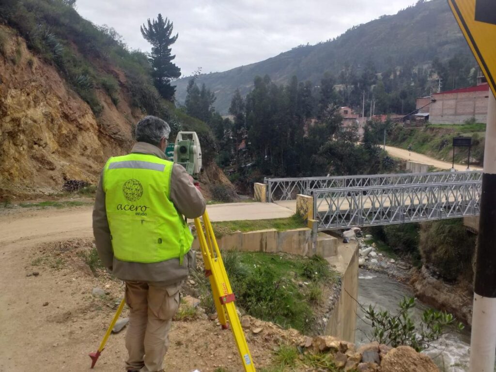
2. Practical Case of Continuous Surveying in Action

There are cases in which a large-scale construction project requires great topographical efforts continuously throughout the construction process; This process is called continuous surveying. If initial surveying provides the foundation, continuous surveying ensures that the infrastructure will remain stable and safe throughout the construction process.

Thanks to the advancement and technology of our work, we can provide sensors that will accurately constantly monitor soil deformations, guaranteeing structural integrity and providing adequate data to take corrective actions before a structural collapse occurs.

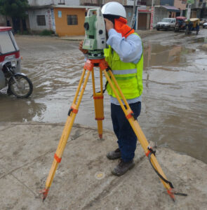
3. Benefits of Continuous Surveying

Continuous surveying goes beyond simple initial measurement. It provides constant monitoring of the work, detecting any unexpected changes, which provides higher levels of security and optimizes resources by preventing problems before they worsen.

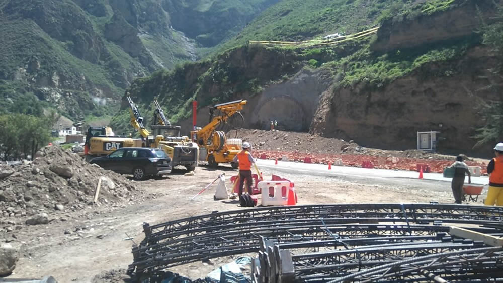
4. Types of Construction that Require Continuous Topographic Monitoring

Not all constructions demand the same level of topographic monitoring. Those of a permanent nature, such as bridges, skyscrapers, tunnels, dams and critical infrastructure projects, benefit significantly from continuous topography. The long-term stability of these structures requires constant attention to ground conditions and possible changes. Topographical surveying is no longer enough.

5. The Crucial Need for Continuous Surveying in Construction Sites

Continuous topographic monitoring stands as a fundamental pillar in risk management and effective planning, ensuring that each construction is a lasting testament to human skill. Ultimately, continuous surveying is not only a safety measure, but a wise investment for the present and future of engineering and construction.

The Total Station in Surveying: An Essential Instrument for Accurate Measurements

total station

One of the most essential and versatile tools used in surveying services is the total station. In this article, we will explore in detail what a total station is and how it is used in surveying.

A total station is an advanced surveying instrument that combines several essential functions in a single device. Unlike traditional surveying instruments such as theodolite and scope, the total station is an all-in-one tool that allows surveyors to make accurate measurements of horizontal and vertical angles, as well as distances, heights and elevations. These measurements are made with remarkable precision, making it an indispensable tool in the field of modern surveying.

Components of a Total Station

Total stations consist of several key components:

  • Theodolite: The theodolite incorporated in a total station is responsible for measuring horizontal and vertical angles with great precision. It allows surveyors to point to specific points on the ground and determine directions and elevations accurately.
  • Distancemeter: Total stations are equipped with a distancemeter that uses laser or electronic technology to measure distances between the total station and the point of interest. This allows obtaining precise coordinates.
  • Spirit Level: A spirit level built into the total station ensures that the instrument is perfectly level, which is essential for accurate angle and elevation measurements.
    Screen or viewer: The total station generally has a screen or viewer where the collected data, such as angles, distances and coordinates, are displayed. Some modern total stations even have touch screens for a friendlier user interface.

Use of the Total Station in Topography

Total stations are used in a wide variety of surveying applications, including:

  • Topographic Surveys: To measure the elevation, distance and direction of points on the Earth’s surface, allowing the creation of detailed topographic maps.
  • Construction project control: In the planning and execution of construction projects, such as buildings, roads and bridges, to ensure that structures are built according to specifications.
  • Property surveying and demarcation: To determine property boundaries and create accurate cadastral plans.
  • Monitoring of deformations and changes: In geodetic studies to measure the deformation of structures or the movement of the ground over time.
  • Geology and geophysics: In geological studies to determine the stratigraphy of the subsoil and in geophysical studies to investigate the properties of the terrain.

Advantages of Total Stations

Using a total station offers several advantages, such as:

  • Greater precision: Allows highly precise measurements of angles, distances and elevations.
  • Efficiency: Simplifies the measurement process by combining multiple functions in a single instrument.
  • Speed: Facilitates obtaining data quickly and efficiently.
  • Data Storage: Many modern total stations can store and transfer data electronically, simplifying further processing of the information.

The total station is an essential tool in the field of modern surveying. Its ability to make accurate measurements of angles, distances and elevations with efficiency and ease makes it an invaluable instrument in a variety of applications, from creating detailed topographic maps to planning and executing construction projects.

Its incorporation of cutting-edge technology has transformed the way surveying measurements are made and has significantly improved the accuracy of the results.

Topographic Survey – Topographic Services

levantamiento topografico en zona rural del peru

Topographic Surveying: An Essential Service for Construction and Project Planning

In the world of construction and architecture, precision is key. The infrastructure that is built must be safe, functional and aesthetically pleasing, but it all starts with a detailed understanding of the terrain on which it will be built. This is where land surveying comes into play, an essential surveying service that measures and represents the characteristics of a land surface. Without a doubt, this process is one of the fundamental pillars in project planning.

apoyo tecnico topografico de acero estudio en la construccion del tunel chacahuaro en lima
TECHNICAL SURVEYING SUPPORT of Acero Study in the Construction of the Chacahuaro Tunnel in the Department of Lima

Fundamental Pillars for Project Planning

Topographic surveying has become a highly specialized discipline that uses advanced techniques to obtain a detailed plan of the terrain. It is not limited to simply drawing a flat map; It goes much further by showing elevations and low areas with an impressive level of detail. In addition, it is capable of identifying and representing existing elements on the ground, such as trees, buildings or roads. This service is the first step towards creating a design that works in harmony with the natural environment.

For construction and architecture companies, surveying services such as land surveying are invaluable. By having precise knowledge of the terrain, architects and engineers can design structures that take advantage of the natural shape of the terrain’s slopes, taking advantage of its natural characteristics. This approach not only promotes the aesthetics and functionality of the design, but also generates significant savings by adapting to the existing topography instead of trying to modify it.

levantamiento topografico en piura peru

Surveying also plays a crucial role in geographic risk management. Nature can be unpredictable, but with the information provided by this service, it is possible to anticipate and manage a series of challenges. For example, flood zones can be detected, which is essential for planning construction projects near bodies of water or flood-prone areas. Likewise, areas of unstable land can be identified, allowing architects and engineers to plan construction processes that anticipate these challenges, thus avoiding costly corrections later in the project.

Furthermore, surveying not only benefits builders and architects, but is also essential in a variety of industries. For example, in the field of agriculture, this technique is used to plan irrigation and crop planting efficiently, taking advantage of the characteristics of the terrain to optimize production. In the energy field, it is used in the planning of wind and solar farms, ensuring that facilities are placed in optimal locations in terms of exposure to the sun and wind. Even in the realm of cartography and geology, topographic surveying is essential for creating accurate maps and understanding the geology of a region.

Surveying is much more than a simple measurement tool. It is an essential service that supports project planning, ensures the safety of structures and enables efficient management of geographic risks. From home construction to large-scale infrastructure projects, this discipline is an integral part of the construction industry and plays a critical role in creating a safe and functional built environment. Therefore, it is no exaggeration to say that land surveying is the foundation on which our world is built.

Other topographic services are:

  • Polygonal Topography
  • Geometric Leveling
  • Photogrammetry
  • LIDAR
  • 3D Laser Scanning

Contact Acero Estudio, a company specialized in topographic studies, we are at your service.

Aerial surveying is getting smarter

Drone

Surveyors and GIS professionals have very high standards when it comes to their tools and their craft. Therefore, it is not surprising that many are turning to drones when requesting a surveying, mapping and 3D modeling service. Drones achieve results that meet surveying accuracy standards and, compared to traditional surveying techniques, dramatically reduce the time, cost and effort required.

Drone surveying is more complicated than taking a few photos from above. This requires several steps, from the preparation of ground control points, through mission planning, to the processing of the images that are captured with the topography software.

Within drone surveying, one technique that has been successful in 3D modeling is the use of oblique drone photogrammetry, in which images are captured with multiple lenses that are mounted together in an array with fixed axis angles. The resulting images reveal details that are sometimes lost when capturing only vertical photographs.

Using this cutting-edge technology, surveyors have the ultimate surveying solution at their disposal, in terms of precision and efficiency. Thanks to the intelligent oblique capture feature, surveyors can now capture and create 3D models of their targets more effectively than ever.

Oblique photography has many advantages. While a vertical angle can help show the location of features such as buildings, streets or open spaces, oblique aerial photos are better at giving a perspective of the appearance of features rising from the ground such as buildings, topography, foliage, etc. in relation to the ground and the horizon.

Other advantages are:

  • Reveals details that might have been obstructed in the vertical view.
  • Facilitates accurate determination of feature elevation.
  • Captures much more relative height data.
  • The position and relative height information obtained from each data set can be compared, contrasted and pooled to obtain relative height information between elements in the target area, producing a map of both position and height data, which It can be represented as a 3D map of the studied area.

However, there are also disadvantages. Due to the number of lenses, the equipment can be very heavy and expensive. A heavier payload means shorter flight times and more time spent changing the drone’s batteries, especially on large-scale surveying missions. On the other hand, if you try to do oblique photogrammetry or 3D modeling with a single camera, many flights are needed, which takes significantly more time.

With the continued increase in the use of drones in surveying and construction, there is a constant need to make their use easier and more economical, in terms of time and cost. Aerial surveying has become smarter and oblique shooting is one such innovation that covers both aspects.

Contact Acero Estudio, a company specialized in aerial photogrammetry; we are at your service.