
What Errors Occur in Topography and How to Avoid Them?
Topography, like any discipline, demands expertise and knowledge to avoid errors and achieve optimal results. [...]
What Types of CAD Services Do We Provide at Acero Estudio?
Companies often recognize Acero Estudio for our expertise in topography survey and BIM consulting services. [...]

Setting Out in Topography: Key to Error-Free Construction
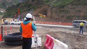
Once a topographic survey has been conducted, companies gain precise information about the land where [...]

Is BIM Suitable for Road Infrastructure Projects?
At Acero Estudio, we are passionate advocates and evangelists of BIM for construction projects. However, [...]

What Types of Clashes Does the BIM Methodology Prevent in Construction Projects?
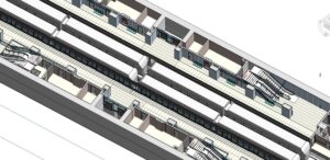
As we have illustrated on several occasions, the BIM methodology is essential in preventing conflicts [...]
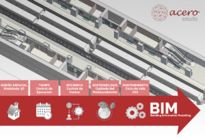
The BIM Methodology: Understanding Its Application in All Phases of a Project
If you’re on this page, you might be wondering whether implementing the BIM (Building Information [...]

What Information Should a Topographic Plan Include?
As mentioned in several of our articles, topography is essential for construction and infrastructure projects [...]
Control Points in Topography
Control points in topography are physical (metal or concrete markers) or digital (points within a [...]

What is Leveling in Topography?
Leveling is a topographic technique used to measure and establish the difference in height between [...]
Version Comparison: Revit 2018 to Revit 2024
In the past five years, BIM has continued its significant progress, driving widespread adoption of [...]
