
Is Real-Time Updating of BIM Models Advantageous?
The BIM methodology offers a significant advantage by enabling real-time functionality. This means that any [...]

Is BIM Suitable for Infrastructure Construction?
When it comes to infrastructure, BIM’s uses are significant. BIM is applicable in planning and [...]

Benefits of CAD Outsourcing
Computer-Aided Design (CAD) is a critical tool in creating technical drawings and designs for sectors [...]

The Role of Topographic Surveys in Industrial Project Planning
In industrial construction projects, an accurate topographic survey is essential to mitigate risks such as [...]

BIM vs CAD: What Are the Differences and Which Is Better for Your Project?
In the world of construction and design, two tools have dominated over the past few [...]
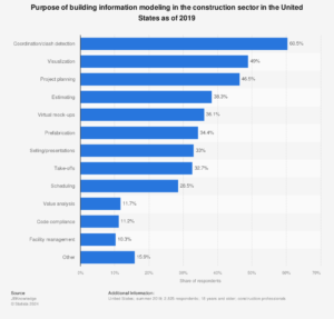
10 Principal Uses of the BIM Methodology
As we always emphasize on our website, social media, or through our technical teams in [...]

What is a Total Station in Surveying?
One of the most traditionally used tools in surveying companies is the total station. This [...]
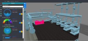
Similarities and Differences between BIM Methodology and Digital Twins
In the field of construction, architecture, and building management, the BIM methodology and Digital Twins [...]
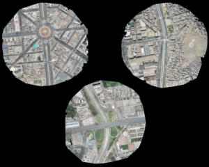
Strategies for Improving Pedestrian Accessibility through Aerial Photogrammetry
Pedestrian accessibility in public infrastructure is crucial for the efficient and safe mobility of people. [...]

What Are the Marks Drawn During a Topographic Survey For?
As you already know, topographic studies are of great utility to the construction and architecture [...]
