
What Is Topography and What Is It Used for?
Topography is a fundamental discipline in engineering, architecture, and construction. Its main purpose is to [...]
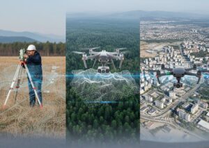
Geomatics: When to Use Each Survey and Why
Geomatics integrates a set of technologies and methodologies focused on capturing, analyzing, and interpreting geospatial [...]

How our BIM Service helps you achieve a more feasible project
Efficiency and feasibility are key factors for the success of any project. Through our bim [...]

What Is BIM Energy Analysis and What Is It Used For?
There is no doubt that energy efficiency is a key factor in modern construction projects, [...]

From the Gantt Chart to the 4D BIM Model
Time planning is one of the most critical aspects of construction projects. Traditionally, the Gantt [...]

Guide for the Quality Audit of BIM Models in Projects
When it comes to large-scale projects, the quality of BIM models becomes a critical factor [...]

What Does the Price of a Topographic Survey Depend On?
The price of a topographic survey is not a standard value, as each project presents [...]
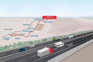
How Topography Is Vital for Mega Projects: The Case of the New Central Highway in Peru
Topographic studies are essential for the construction of large-scale transportation infrastructures that require detailed information [...]

Use of LIDAR in topography for mining
Modern mining, which processes hundreds of tons each day, requires precise and reliable information to [...]

BIM Modeling: What Is It?
BIM modeling is a 3D development process that basically consists of creating a digital model [...]
