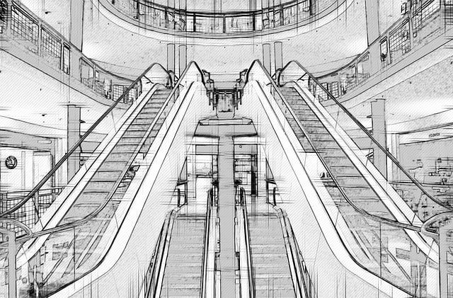
Álex Ruiz will present the presentation “Laser scanner and point cloud” as an expert at EXPOBIM 2020
“EXPOBIM” 2020 will be held on November 5, 6 and 7, where Álex Ruiz, from the Acero Estudio subsidiary in Peru, will present the symposium “3D Laser Scanner and Point Cloud” at the Catholic University of Lima. The conference will be broadcast via Zoom and Facebook live and will feature prestigious international experts as speakers.
On Thursday the 5th, the engineer Pablo Zúñiga Guevara will start the event, with his presentation “BIM application in construction projects in Colombia”, and will be followed by the architect Sergio Villanueva-Meyer with “Innovation methodologies in the construction industry”.
On Friday, the two presentations are “BIM from the technical side”, by engineer Jonattan Gómez Araya and the day will end with Renzo Ríos Rugel who will talk to us about “Automation in BIM”.
The last day, Saturday the 7th, will begin with “Infrastructure in BIM” whose speaker is the engineer Alejandro Alvarazo Lezama, and to finish “Expo BIM” the symposium “Laser scanner and point cloud” will be presented by Álex Ruiz, expert in photogrammetry and 3D laser scanning from the Acero Estudio team, BIM consultants.
An essential event for all of us who work with BIM in the construction sector.
LIDAR (Light Detection and Ranging) technology is a fundamental tool in the infrastructure construction industry. Thanks to its laser pulses, it helps us measure distances, depth differences in the terrain and of course the creation of precise three-dimensional models of a studied area. In this article we will try to review the benefits of LIDAR technology for the construction of infrastructure.
Accurate terrain mapping
With LIDAR technology our engineers can create detailed topographic maps of any terrain, which is essential for planning infrastructure construction projects. Thanks to a record generated with LIDAR, your project can have precise information about the elevation of the terrain, slope and surrounding vegetation.
This information will be of great help to take advantage of the geographical advantages of any area as well as avoid risks in the construction and design of roads, bridges, dams and other projects.
Obstacle detection
One of the most important benefits of LIDAR is its ability to detect and map obstacles even in areas with lush vegetation or areas with buildings or electrical cables. This is crucial to ensure the safety of construction, workers and avoiding problems with existing structures.
Efficient design and planning
LIDAR helps us have accurate data that allows engineers and architects to carry out more efficient infrastructure design. Having a detailed understanding of the terrain and obstacles can improve road alignment, the location of bridge piers, and also the layout of underground infrastructure.
Advantages of LIDAR for Quality Control and Project Monitoring
Take into consideration that the advantages of LIDAR are not only appropriate before the execution of projects but also during and after for quality control tasks, monitoring the resistance of structures, etc. And with respect to infrastructure projects, it is worth noting that LIDAR has been used successfully in a wide range of construction projects such as:
Construction of roads and highways.
Flood management and drainage infrastructure.
Monitoring of electrical transmission lines.
Urban planification.
Now that you know more about the advantages and benefits of LIDAR, we invite you to contact us about our LIDAR services. Contact us today, we are here to support you.
You know the development of projects without using CAD tools is inconceivable. These tools have become a necessity to achieve good results in the design process of projects of all kinds.
The deficiencies that arise due to insufficient knowledge of this methodology can be overcome by seeking the assistance of professional external services. If your company has a concept of what it wants to represent in a project, the involvement of a specialized company will provide greater efficiency, excellence, and results in the preparation of the necessary documentation for your projects, reaching very high levels of productivity and positioning you ahead of your competitors.
The external support of an expert CAD services company, such as Acero Estudio, not only helps by providing high-quality documentation for your project but also optimizes all your time through their experience.
Take advantage of the expertise of professionals to get the best result, CONTACT US!
The infrastructure development requires, precision, innovation, and efficiency, these are key elements for success. Acero Estudio, through its CAD design service contributes to the creation of detailed plans for the Valencia Ring Road in Spain.
Background of the project
Valencia, a city steeped in history and modernity, required a state-of-the-art transportation system to accommodate its growing population and enhance connectivity. The ambitious Valencia Ring Road project aimed to address these needs.
Recognizing the importance of CAD in modern engineering, Acero Estudio took the lead in providing CAD services for the Valencia project. The implementation of CAD technology allowed for the creation of highly detailed and accurate plans, ensuring that every aspect of the road’s design met the highest standards.
Key Features of Our CAD Service:
Our team employed advanced CAD tools to ensure precise mapping of the road. Every curve, intersection, and elevation was meticulously detailed, minimizing the margin for error and enhancing overall accuracy.
The use of CAD streamlined the design process, allowing for faster iterations and modifications. This efficiency not only saved valuable time but also contributed to the overall project timeline.
Our CAD expertise facilitated the incorporation of innovative design elements into the plans. This included optimal traffic flow patterns, safety enhancements, and sustainable features.
CAD’s collaborative capabilities allowed for seamless communication between different stakeholders involved in the project. Engineers, architects, and project managers. They could easily share and modify design elements, fostering a more integrated approach.
One of the main uses of CAD is to provided stakeholders with a clear and realistic view of the proposed infraestructure. This not only aided in decision-making but also ensured that the project met the expectations of all involved parties.
The successful implementation of Acero Estudio’s CAD design service significantly contributed to the realization of the Valencia Ring Road. The precision in planning, efficiency in execution, and innovative design elements have set a new standard for infrastructure development in the region.
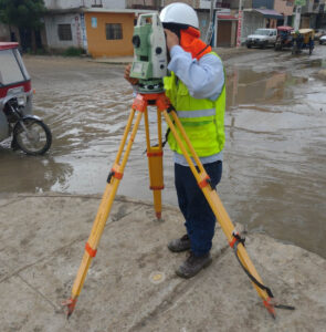
Topographic Surveying: An Essential Service for Construction and Project Planning
In the world of construction and architecture, precision is key. The infrastructure that is built must be safe, functional and aesthetically pleasing, but it all starts with a detailed understanding of the terrain on which it will be built. This is where land surveying comes into play, an essential surveying service that measures and represents the characteristics of a land surface. Without a doubt, this process is one of the fundamental pillars in project planning.
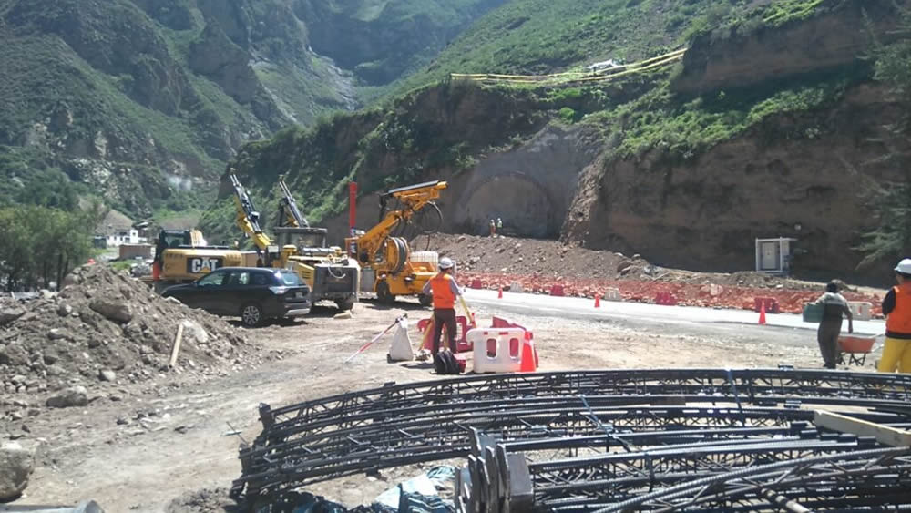
TECHNICAL SURVEYING SUPPORT of Acero Study in the Construction of the Chacahuaro Tunnel in the Department of Lima
Fundamental Pillars for Project Planning
Topographic surveying has become a highly specialized discipline that uses advanced techniques to obtain a detailed plan of the terrain. It is not limited to simply drawing a flat map; It goes much further by showing elevations and low areas with an impressive level of detail. In addition, it is capable of identifying and representing existing elements on the ground, such as trees, buildings or roads. This service is the first step towards creating a design that works in harmony with the natural environment.
For construction and architecture companies, surveying services such as land surveying are invaluable. By having precise knowledge of the terrain, architects and engineers can design structures that take advantage of the natural shape of the terrain’s slopes, taking advantage of its natural characteristics. This approach not only promotes the aesthetics and functionality of the design, but also generates significant savings by adapting to the existing topography instead of trying to modify it.
Surveying also plays a crucial role in geographic risk management. Nature can be unpredictable, but with the information provided by this service, it is possible to anticipate and manage a series of challenges. For example, flood zones can be detected, which is essential for planning construction projects near bodies of water or flood-prone areas. Likewise, areas of unstable land can be identified, allowing architects and engineers to plan construction processes that anticipate these challenges, thus avoiding costly corrections later in the project.
Furthermore, surveying not only benefits builders and architects, but is also essential in a variety of industries. For example, in the field of agriculture, this technique is used to plan irrigation and crop planting efficiently, taking advantage of the characteristics of the terrain to optimize production. In the energy field, it is used in the planning of wind and solar farms, ensuring that facilities are placed in optimal locations in terms of exposure to the sun and wind. Even in the realm of cartography and geology, topographic surveying is essential for creating accurate maps and understanding the geology of a region.
Surveying is much more than a simple measurement tool. It is an essential service that supports project planning, ensures the safety of structures and enables efficient management of geographic risks. From home construction to large-scale infrastructure projects, this discipline is an integral part of the construction industry and plays a critical role in creating a safe and functional built environment. Therefore, it is no exaggeration to say that land surveying is the foundation on which our world is built.
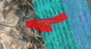
We are advancing at a good pace in the Topography works for the project:
“Riverside defenses of the Casma and Huarmey rivers”.
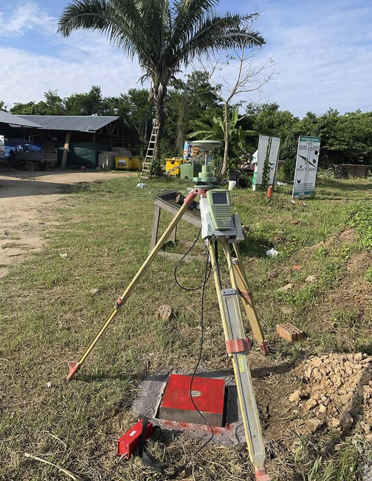
Acero Estudio LATAM, in Peru, provides field and cabinet services for the development of this project included in the Comprehensive Plan for Reconstruction with Changes (PIRCC) to restore all the physical infrastructure damaged and destroyed by the El Niño Coastal Phenomenon in 13 regions of the country: Áncash, Arequipa, Ayacucho, Cajamarca, Huancavelica, Ica, Junín, La Libertad, Lambayeque, Lima, Loreto, Piura and Tumbes.
Our participation in this project consists of the topographical survey and preparation of the digital terrain model of the area in which the actions of this project are carried out in the preparation of topographic plans and records and the generation of volumetric reports on earthworks and civil works. . We also participate in meetings to reconcile the distance measurements of haulage routes and the volume of production of various materials.
Specific topographic surveys have been carried out to represent the terrain and the various existing elements contained in the digital model at different scales, such as bridges, intakes and other structures using different technologies, total station, GPS, drones, Lidar, echo sounder and level.
Among others, we use PIX4Dmatic software, state-of-the-art photogrammetry software for terrestrial, large-scale and corridor mapping.
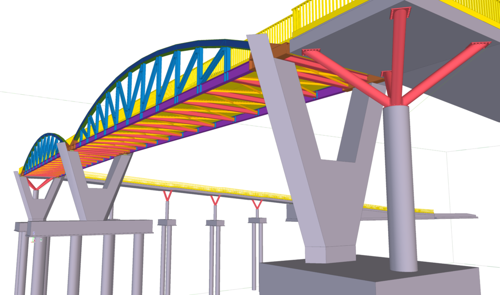
Tekla software offers high value solutions in the engineering industry focused on structural design, manufacturing and assembly, which guarantee the constructability of projects and the creation of highly detailed models.
The applied technology allows contractors to manage risk and plan the construction process accurately by creating safer structural models, where the analysis of their data allows informed decisions to be made at all stages of the project and minimizes uncertainties. .
Currently, efficient collaboration and communication between stakeholders, as well as interoperability between the different design and calculation software in the industry, are crucial for the success of any project, especially if it is framed in BIM work methodologies. .
Tekla software is a specific response to an area of the industry that demands highly developed structural information models, handling data with greater accuracy and more precise calculations.
Acero Estudio has extensive experience in the use of this tool as a result of the practice and continuous training of our staff.
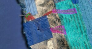
We are advancing at a good pace in the works of the Topography Study for the project:
“Riverside defenses of the Lacramarca river”.
From Acero Estudio LATAM, in Peru, we provide field and cabinet services for the development of this project included in the Comprehensive Plan for Reconstruction with Changes (PIRCC) to restore all the physical infrastructure damaged and destroyed by the El Niño Costero Phenomenon in 13 regions of the country: Áncash, Arequipa, Ayacucho, Cajamarca, Huancavelica, Ica, Junín, La Libertad, Lambayeque, Lima, Loreto, Piura and Tumbes.
Our participation in this project consists of the topographical survey and preparation of the digital terrain model of the area in which the actions of this project are carried out in the preparation of topographical plans and records, as well as generating the volumetric reports on earthworks and civil works. . We also participate in meetings to reconcile the distance measurements of haulage routes and the volume of production of various materials.
Specific topographic surveys have been carried out to represent the terrain and the various existing elements contained in the digital model at different scales, such as bridges, intakes and other structures using different technologies, total station, GPS, drones, Lidar, echo sounder and level.
Among others, we use PIX4Dmatic software, state-of-the-art photogrammetry software for terrestrial, large-scale and corridor mapping.
We thank ARTIFICIAL for the trust placed in our team.
This means of data capture is transforming work methods and simplifying all processes as it offers great advantages derived from its use. At Acero Estudio we are specialized in scanning and modeling buildings, railway lines and industrial plants among other.
This technology is useful in all kinds of scenarios. In any environment it is a valid tool, although a priori it is not considered the tool to use.
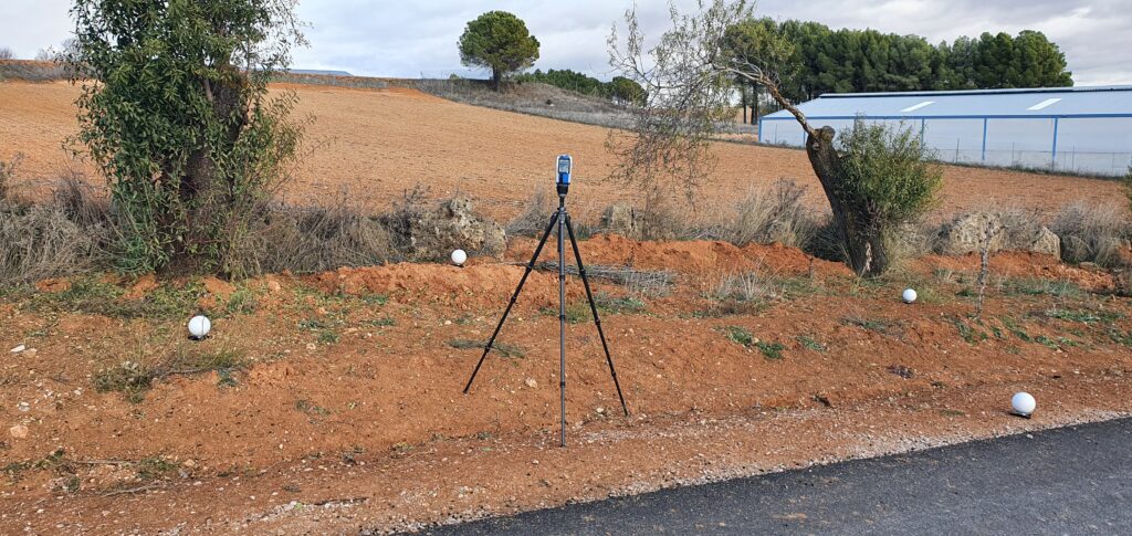
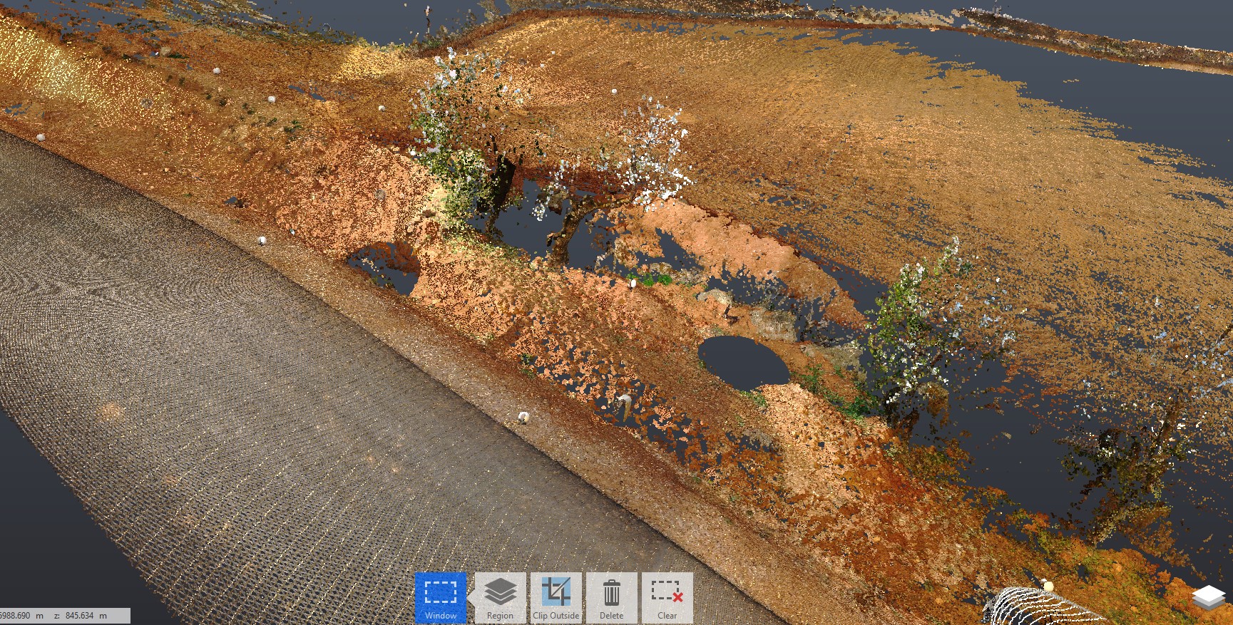
Today we show you a 3D laser scan of several plots in a rustic setting. With the help of spheres, which we have already told you about in another article, the complete scenario of the area to be studied was captured.
We leave you a photo so you can see the final result.
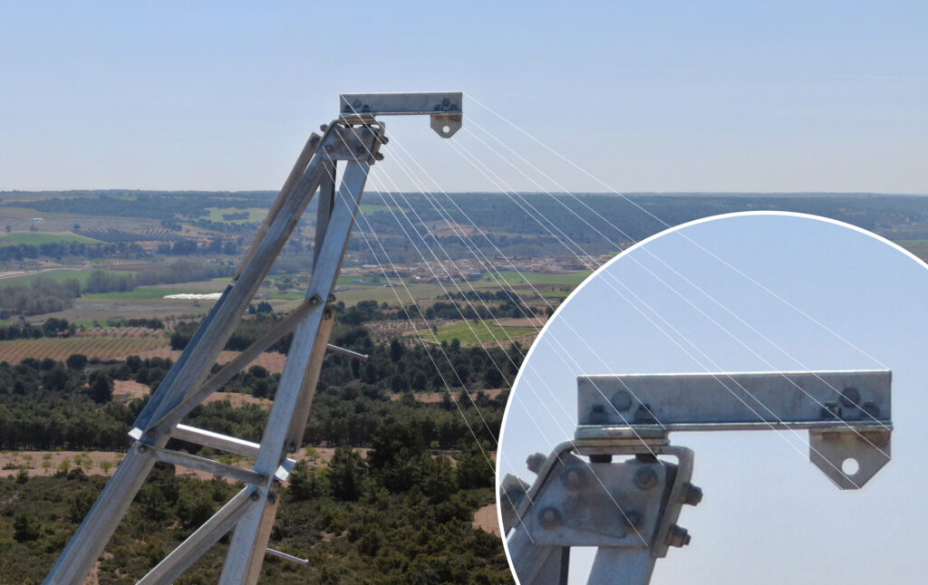
The effectiveness of drones in taking images is indisputable, for example, in wind farm inspections they have a great advantage since they reduce time and costs, and prevent operators from having to access their high-rise facilities.
But today we want to talk to you about the quality of the cameras that drones incorporate, capturing images at height has taken a giant step forward thanks to the use of these small devices.
When purchasing a drone, you must take into account the camera you are going to choose in the event that you opt for one with an integrated camera or one in which you can install your own camera and we must not forget that image stabilization is one of the key aspects for a correct recording or photography.
At Acero Estudio we have a fleet of Drones with 24-48 mm Optical Zoom, 48 MP Super Resolution photos, FHD Video with 4× Zoom to offer you the best service on the market since we have professionals with extensive experience in the audiovisual sector. We not only offer data collection but also the making of subsequent videos with all the post-production work that needs to be incorporated.
With all the photos and videos, and thanks to the zoom of the high-quality cameras that our drones have, they will be able to detect defects and damage at the moment, allowing solutions as soon as possible.
Nuestra web está en reestructuración. Agradecemos su comprensión si algún componente del sitio no funciona correctamente. Para contactarnos: comercial@aceroestudio.com