Topography, like any discipline, demands expertise and knowledge to avoid errors and achieve optimal results. In our field, accuracy is critical, as even minor errors can accumulate and lead to significant negative consequences in engineering projects if not detected in time.
The main types of errors in topography are systematic errors and accidental errors. Let’s understand how they arise and how to prevent them to ensure the quality of the results.
Systematic Errors
These are deviations that occur due to equipment malfunctions, incorrect calibrations, improper procedures, or environmental factors. Systematic errors tend to repeat under the same conditions and, if not corrected, can lead to consistently inaccurate results.
Examples of systematic errors:
- Uncalibrated total stations, damaged leveling instruments, etc.
- Environmental factors such as light, metal expansion due to heat, or fog affecting instrument readings.
Accidental Errors
These are deviations caused by unpredictable variables such as human error or accidental instrument movements. While they are unavoidable to some extent, these errors are typically minor when proper procedures are followed.
Examples of accidental errors in topography:
- Instrument reading errors due to operator distraction or carelessness.
- Vibrations in the terrain caused by machinery or other external factors.
How Do We Prevent These Errors?
As a specialized topography company, we implement procedures to minimize errors and ensure the reliability of our work. Below are the measures we take:
To Prevent Systematic Errors:
- Regular maintenance of equipment: We have preventive maintenance plans to ensure all instruments function perfectly.
- Calibration and verification: Total stations and levels are calibrated and checked before any project.
- Evaluation of atmospheric corrections: Adjustments are made for environmental factors, such as material expansion on hot days.
- Deviation tests: These tests are conducted to identify potential systematic errors.
To Prevent Accidental Errors:
- Continuous training: We provide regular training and updates to our personnel.
- Advanced technology: Our tools feature integrated viewers and systems to reduce common errors.
- Comparative measurements: We conduct multiple measurements to identify and eliminate inconsistencies.
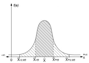
The Gauss Curve and Its Application in Topography
The distribution curve, or Gauss curve, helps identify potential errors by analyzing deviations in the data. It allows us to distinguish between systematic and accidental errors effectively.
This statistical tool enables informed decisions about the quality of the collected data and the implementation of corrections when necessary.
To achieve precise and reliable results for your projects, it’s essential to work with a specialized topographic survey company like Acero Estudio. Our team leverages cutting-edge technology and adheres to high-quality standards to ensure accurate, error-free measurements.
With our topography services, we will provide you with the precise information about your terrain, giving your engineering or architectural projects a solid and accurate foundation.
Contact us today! We’re here to assist you with all your topography needs.