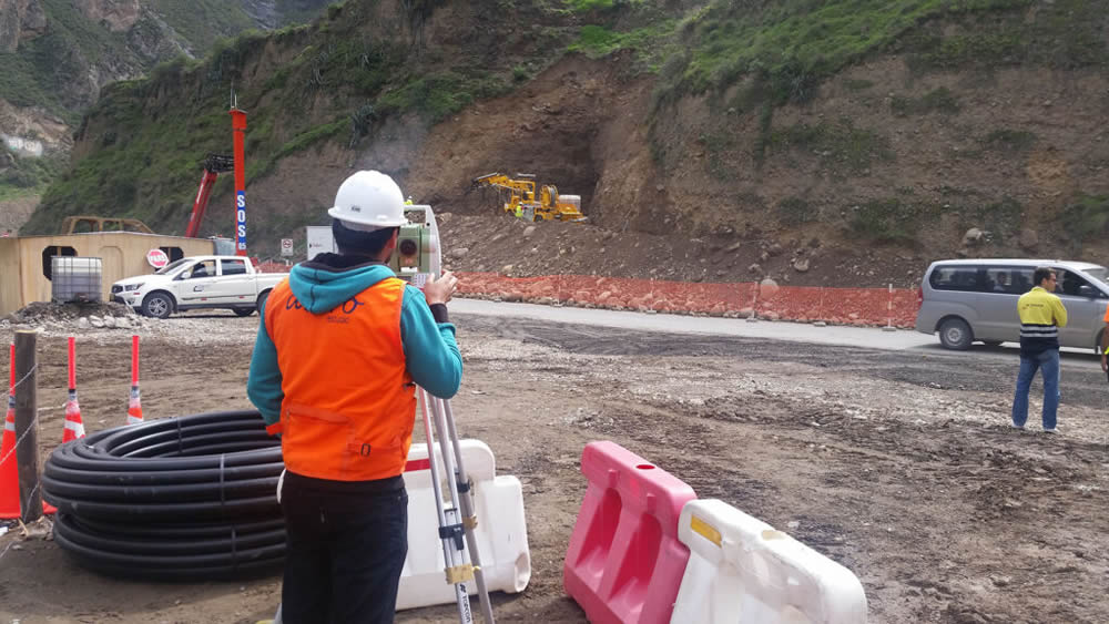
Once a topographic survey has been conducted, companies gain precise information about the land where construction will take place. A topographic setting-out is the process of validating the data from the prior survey to initiate the construction process.
Why is setting-out important?
A setting-out ensures that the structure is correctly positioned, avoiding errors that could lead to additional costs and project delays. While there are usually ways to validate information from a topographic survey, setting-out minimizes the risk of any erroneous values persisting.
How do we carry out our setting-out process?
Preparation: We analyze the technical design and determine the key points to be marked on the site.
Positioning: Reference points are established using tools like total stations, optical levels, or GPS.
Marking: Stakes, lines, and other marks are placed to serve as guides for construction teams.
Applications
Construction of buildings, roads, and bridges.
Industrial facilities and plants.
Urban development projects and public utility networks.
If you’ve conducted topographic surveys and need validation of the data, contact Acero Estudio. With 26 years of experience, we specialize in topographic survey services, ensuring precise construction in the right location. Contact us today!
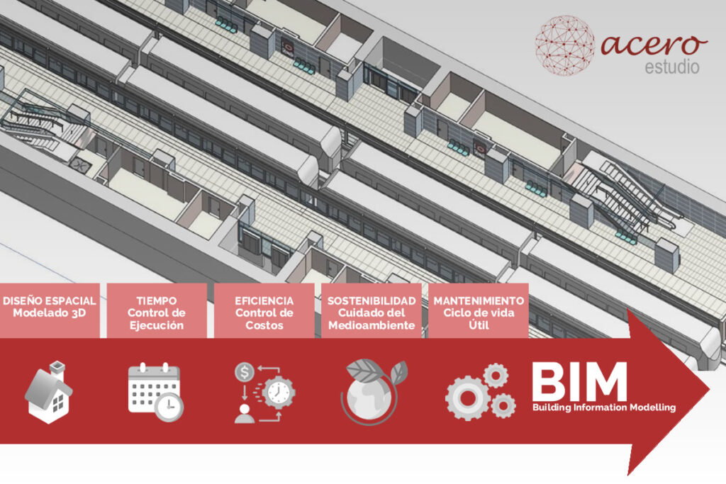
At Acero Estudio, we are passionate advocates and evangelists of BIM for construction projects. However, some clients ask whether the functionality of the BIM methodology is equally useful for simpler but larger-scale paper-based projects, such as road infrastructure.
The notion that BIM might not be necessary for infrastructure projects often considers only the physical components of road infrastructure, such as a highway. However, it may overlook the full power BIM offers for project management, including:
Calculation and projection of required materials
Equipment and schedule management
Purchase and procurement planning
Information related to infrastructure management throughout its lifecycle
Better planning with BIM
Initial Phase of a Road Infrastructure Construction Project
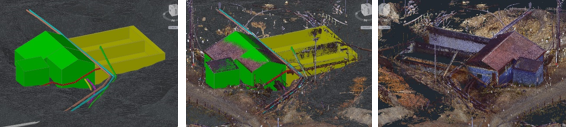
At this stage, BIM demonstrates immense potential with tools and utilities like Scan-to-BIM. For instance, using a 3D laser scanner, we can rapidly and accurately convert area data into BIM modeling, offering precision, speed, and efficiency.
During the Execution of the Project
BIM enhances operational efficiency through better coordination of teams, keeping all units informed and helping anticipate potential risks and clashes. Additionally, its material management components prevent over-purchasing, reducing waste and increasing the profitability of the construction company.
Post-Construction Phases
BIM is invaluable for maintenance and precise monitoring of areas prone to degradation or requiring close supervision. Moreover, BIM models provide accurate and comprehensive information for potential future expansions, ensuring better outcomes in every phase.
If you’ve decided to leverage Acero Estudio’s expertise as a BIM consulting firm, don’t hesitate to contact us. Our specialists can transfer knowledge to your team, helping you minimize risks through proper monitoring and guidance.
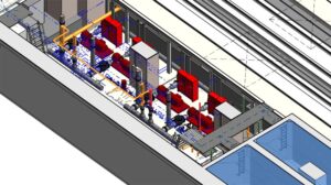
As we have illustrated on several occasions, the BIM methodology is essential in preventing conflicts in construction projects. These conflicts are often referred to as clashes, as they involve collisions or inconsistencies that, thanks to BIM, can be avoided due to the logic embedded in its software.
Physical Clashes
These occur when two or more elements of a project occupy the same physical space. In traditional construction, design tools are not updated in real time or are often not incorporated into the main plans, leading to issues during execution.
These are serious problems that can affect structures, such as:
A pipe running through a structural beam
Water or ventilation ducts colliding with electrical installations
Mechanical equipment lacking sufficient space for maintenance or installation
BIM identifies these interferences through “clash detection” analysis, allowing for appropriate corrections in the model before the issue results in a poorly executed construction.
Functional Clashes
These involve incompatibilities in the performance or operation of systems, including electrical, plumbing, and HVAC systems. Examples of functional clashes include:
Inadequate ventilation in a space due to poor placement of HVAC systems
Electrical systems designed for loads higher or lower than required
Hydraulic connections incompatible with equipment specifications
Design Issues
These relate to aesthetics, accessibility, or regulatory compliance. In every construction project, installations must adhere to regulations and good design practices that ensure proper ventilation, lighting, and pedestrian circulation.
By using pre-developed BIM models, we ensure compliance with all parameters of the original design and can identify the proper placement of installations in time to achieve an optimal building design.
Planning and Scheduling Errors
Thanks to 4D simulation tools, BIM incorporates the dimension of time, helping to avoid scheduling problems such as:
Equipment installation being scheduled before the space is built
Overlapping activities that cause delays or additional costs
As you can see, the benefits of BIM in construction enable effective project management, planning, and execution with accurate and up-to-date information.
If you want to implement this important methodology in your projects, it’s crucial to have proper training. Our BIM consultancy ensures the safe implementation of BIM at any stage of development. Reduce risks, rework, and costs with Acero Estudio, a company specialized in BIM in Spain and Peru.
Contact us today and let’s enhance your BIM models together!
If you’re on this page, you might be wondering whether implementing the BIM (Building Information Modeling) methodology in your projects is truly relevant or if it’s just a trend that will soon be replaced by another workflow system.
Let us assure you that BIM is here to stay. In the construction and architecture industries, it has become an essential tool for large-scale and complex projects because it facilitates work throughout the entire lifecycle of a project—from design and construction to delivery and building maintenance.
If you think BIM is unnecessary, consider that many countries, including the United Kingdom, Denmark, Finland, Sweden, Norway, Australia, and Singapore, already mandate BIM for state construction projects. In this brief article, we will show you how BIM methodology is applied in each phase of a project.
PROJECT PLANNING AND DESIGN
This is the initial stage of a construction project, where BIM modeling begins. It allows the creation of preliminary sketches of 3D models that link geometry with site characteristics. At this stage, critical information about structural materials and costs is also defined. The benefits of BIM during this phase include:
Enabling visualization of the project.
Enhancing coordination among professionals.
Improving the accuracy of cost calculations for procurement.
For example, in an architectural project, BIM can simulate the behavior of natural lighting in a building or estimate energy consumption, optimizing the design from its conception.
BIM Model
PRE-CONSTRUCTION
In this phase, the BIM model evolves, becoming more detailed and incorporating schedules, costs, and resource allocation for the project. As the project progresses, the level of detail in the 3D model increases with higher Levels of Development (LOD).
Key benefits include:
Task definition using 4D models (time and space).
Improved planning for subcontractor work.
Reduced risks of cost overruns and delays.
CONSTRUCTION PHASE
During the construction process, BIM software serves as a centralized and up-to-date information hub, keeping all teams informed about changes, delays, or incidents that may arise. Early warnings minimize issues, significantly reduce errors, and prevent rework. BIM’s benefits during this phase include:
Centralized monitoring of progress and schedules.
Resource and materials management.
Quality control.
Cloud repositories also enable technical teams to access information about specific parts of the project anytime, anywhere.
MAINTENANCE AND OPERATION OF THE BUILDING
The utility of a BIM model doesn’t end with construction. With the help of various software packages and extensions, BIM allows for projections of maintenance for critical areas, making it a vital tool for managing the constructed asset.
Tracks critical components requiring maintenance.
Updates the model as needed.
Enables operational efficiency analysis.
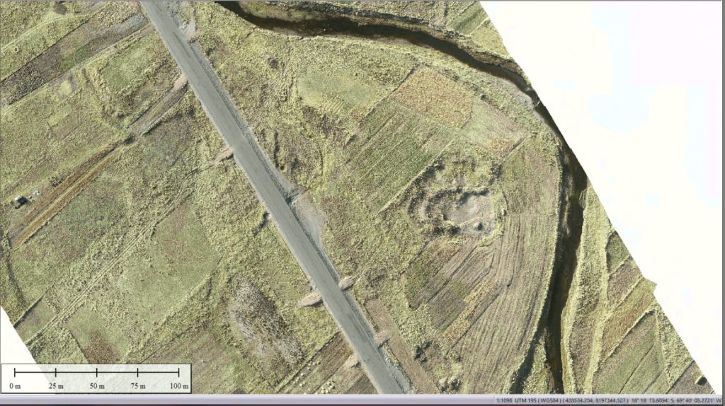
BIM model of transportation infraestructure
DEMOLITION OR RENOVATIONS
Even at the end of an asset’s lifecycle, BIM remains valuable. It improves processes for renovations or demolition, if applicable. In both scenarios, BIM allows for efficient planning with minimal financial impact.
Is Your Team Ready to Implement the BIM Methodology in Your Projects?
If not, don’t worry. At Acero Estudio, we specialize in BIM and offer exceptional BIM Consulting Services to help manage your projects while training your teams. Our BIM consultants have extensive experience. Avoid risks and contact us today—we are here to help.
As mentioned in several of our articles, topography is essential for construction and infrastructure projects because it provides a precise understanding of the terrain, including measurements, slopes, and other vital characteristics for comprehensive data.
After conducting a topographic survey, the surveying company will deliver the topographic study (preferably in both physical and digital formats), which should include the following information:
1. Basic Information of the Plan
Project identification, location, and date of the plan’s creation.
Scale used, clearly indicated to ensure dimensions are understandable and comparable.
Coordinates in a standard reference system (such as UTM or WGS84) to accurately locate points on the terrain.
2. Terrain Features
Precise representation of terrain elevation, with intervals appropriate to the project’s complexity.
Indications of areas with significant slopes that may affect the design or construction.
Identification of natural elements such as rivers, ravines, mountains, or depressions.
3. Present Elements
Details of roads, buildings, pipelines, electrical poles, etc.
Information about wooded areas, cultivated fields, cleared land, water sources, etc.
Geodetic markers or topographic benchmarks used as references.
4. Methodology and Tools
Confirmation of whether total stations, drones with photogrammetry, LIDAR systems, or high-precision GPS were used.
Information about the margin of error to ensure data reliability.
5. Compatibility and Deliverables
Digital files in CAD formats (such as DWG) and GIS formats (such as SHP), along with printed copies if required.
Longitudinal and cross-sectional profiles, digital terrain models (DTMs), and orthophotos, if the project requires them.
6. Certifications and Support
Guarantee that the work complies with local and international regulations.
Signature from specialists, such as a certified surveyor or engineer.
Advantages of a Topographic Survey with Acero Estudio
Acero Estudio, a company specializing in topographic survey, recommends using surveying to avoid construction risks. Our services help you:
Minimize risks in plan design.
Avoid flooding risks or improper project placement.
Contact us to discuss how we can support your project development. With 25 years of experience, we are at your service.
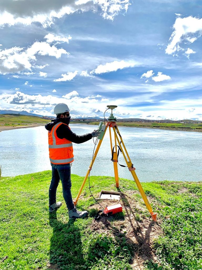
Control points in topography are physical (metal or concrete markers) or digital (points within a digital model) geographic references used to ensure accuracy and consistency in topographic surveys. These points are established with known coordinates and serve as a foundation for precise terrain measurement and mapping.
Benefits of Control Points in Topography
The use of control points provides several benefits, such as:
Ensuring precision in collected data by correcting potential equipment errors.
Guaranteeing consistency between different surveys, facilitating data comparison in long-term projects.
Helping optimize time and resources by reducing the need for subsequent corrections, ensuring reliable results from the outset.
Applications of Control Points
Control points are employed in various techniques, including:
Drone photogrammetry
Topographic leveling
Geodetic surveys
For example, in a road construction project, control points help define precise alignments and elevations, ensuring the design is executed in accordance with the projected plans.
At Acero Estudio, we specialize in topographic survey services such as land surveys and advanced technologies like drone photogrammetry. If you’re looking for precision and efficiency in your projects, contact us. We are ready to provide high-quality solutions tailored to your needs.
Leveling is a topographic technique used to measure and establish the difference in height between specific points on a terrain. This process makes it possible to understand variations in the surface’s relief, which is essential for accurately representing the topography of an area and preparing the foundation for various types of construction.
Sectors and Types of Construction Where Leveling is Used
Road and Highway Construction: Used for planning and adjusting slopes and route alignments.
Civil Engineering Projects: Essential in projects involving bridges, dams, and tunnels, where precision in elevation is critical.
Buildings and Urban Works: Ensures a flat, stable surface before constructing commercial, residential, and industrial structures.
Hydraulic Works: Key for building canals, sewer systems, and irrigation systems, ensuring the correct direction and flow of water.
Agriculture and Landscaping: Facilitates soil leveling for agricultural projects and garden design, promoting better water distribution and land use.
Advantages of Leveling in Topography
Precision in height measurement
Optimization of resources and materials in construction
Reduction of risks from settlement or inclination of structures
Increased safety in civil works
Greater accuracy in slope and drainage control
Instruments and Complexity According to Type of Leveling
Geometric Leveling: Requires an optical or digital level, which offers high precision and is relatively easy to handle, though it does require basic technical training.
Trigonometric Leveling: Uses theodolites or total stations, allowing for height calculations on difficult terrains. This method is more complex, as it demands trigonometric calculations and advanced experience.
Barometric Leveling: Carried out with barometers or altimeters, it is less precise than the other methods but useful for extensive or mountainous areas. Its complexity is low, though accuracy depends on atmospheric conditions.
Trust Acero Estudio for Your Topographic Projects
At Acero Estudio, we specialize in topography and surveying services with precision. Our team uses advanced technology and has industry experience, guaranteeing accurate measurements and comprehensive support at every stage of your project. Contact us for professional advice and quality results in your construction and engineering projects!
Regarding topography, it is often believed that this study is only necessary at the beginning of construction work; however, this view does not fully reflect the true purpose of a topographic survey.
It is essential to consider that these studies, in addition to providing a precise view of the terrain’s characteristics, can help us identify changes in the alignment of structures as they settle, ensuring the correct placement of structures and helping to prevent issues that may arise from discrepancies in elevation, alignment, and terrain configuration. Without this detailed information, construction can face significant risks that impact both the safety and functionality of the structure.
Precision control and alignment: Surveys help verify that all elements of the construction are correctly aligned, preventing deviations in walls, columns, and foundations.
Minimizing structural risks: Detecting anomalies in the terrain, such as sinking or landslides, allows for preventive actions and plan adjustments to ensure structural stability.
Efficiency in material usage: Knowing the precise terrain profile enables optimization of the required material quantities, reducing waste and additional costs.
Mitigating legal issues and conflicts: Accurate surveys ensure that construction is carried out in the correct location and within property boundaries, avoiding property disputes and legal issues.
Historical Case: The Leaning Tower of Pisa
A famous example of the consequences of inadequate planning and lack of detailed topographic and geotechnical studies is the Leaning Tower of Pisa in Italy. Construction of this tower began in 1173, and due to the lack of thorough terrain studies, the tower’s foundations were insufficient to support its weight on soft, uneven ground. This caused the tower to begin leaning during its construction, creating a significant risk of collapse.
With today’s advances in topography, the leaning and structural problems of the Tower of Pisa would have been detected much earlier, allowing for design or foundational adjustments to prevent the tilt. Today, this tower remains an example of the importance of conducting topographic and geotechnical studies, not only at the beginning but at every stage of a construction project, to ensure the stability and safety of buildings.
In the past five years, BIM has continued its significant progress, driving widespread adoption of platforms like Autodesk Revit, which enables architecture, engineering, and construction (AEC) teams to collaborate in real time and efficiently manage all stages of a project.
Revit, Autodesk’s leading software for BIM modeling, has continuously integrated improvements in its versions from 2018 to 2024, expanding its capabilities for increasingly sophisticated collaboration, precision, and visualization.
Key Improvements in Revit Versions 2018 to 2024
Revit 2018: Enhancements in editing complex walls, 3D reinforcement, and new graphic filters.
Revit 2019: Support for perspective views and a new rendering engine.
Revit 2020: Introduction of the “Path of Travel” tool and improvements in MEP systems analysis.
Revit 2021: New cloud collaboration tools and advanced view customization.
Revit 2022: Improved parametric modeling and advanced phase control tools.
Revit 2023: Enhanced interoperability and compatibility with Enscape for visualization.
Revit 2024: Optimization of collaborative BIM workflows and improved review tools.
New Feature Details
Revit 2018:
This version introduced important optimizations for editing complex walls, allowing users to make structural modifications quickly and precisely. It also added a 3D reinforcement feature, aiding projects that require precision in reinforced concrete structures. Additionally, Revit 2018’s graphic filters improved visual clarity and project view customization.
Revit 2019:
In 2019, Autodesk improved the visual interface and support for perspective views, providing designers with a smoother navigation experience within models. The new rendering engine also allowed users to achieve higher-quality renders without impacting overall software performance.
Revit 2020:
A standout feature in this version was the “Path of Travel” tool, which automatically calculates routes within the model, useful for evacuation design and space optimization. Improvements in MEP (Mechanical, Electrical, Plumbing) systems analysis also made working on complex systems easier by enhancing interference detection and load calculation accuracy.
Revit 2021:
Revit 2021 featured essential cloud collaboration tools for projects with remote teams. Advanced view customization provided greater control over model visualization, enabling users to adapt their workspace to the specific needs of each user or project.
Revit 2022:
This version enhanced parametric modeling, increasing flexibility in designing architectural elements. Phase control tools made project planning and management easier, allowing teams to accurately manage the different stages of a construction project.
Revit 2023:
With a strong focus on interoperability, Revit 2023 included significant improvements in compatibility with Enscape, facilitating the creation of high-quality, realistic visualizations directly from the BIM model. This integration was particularly useful for architects and engineers looking to review and share their projects in an attractive and easily interpretable visual format.
Revit 2024: The latest version optimized collaborative BIM workflows, enabling faster and more efficient synchronization among teams. Enhanced review and markup tools facilitate feedback and change tracking, which are essential during the development and construction phases. These updates make Revit 2024 an even more powerful tool for managing complex collaborative projects.
If you’re interested in implementing a BIM solution in your company, project, or even for building management, don’t hesitate to contact Acero Estudio. We specialize in BIM consulting and have a team of experts in Revit.
Let’s talk, find points of support, and consolidate your ideas. We’re at your service.
Topographic studies, also known as topographic surveys, are a fundamental tool in engineering, construction, architecture, and urban planning due to the valuable information they provide about the terrain.
There are various types of topographic surveys, each with specific objectives adapted to the needs of your project. Below, we describe the main types of topographic studies, each with its respective objectives.
Geodetic Surveys
Geodetic surveys are essential for precise topographic mapping. Their objective is to create a framework of reference points with exact coordinates through the use of global navigation satellite systems (GNSS).
These surveys are crucial for large-scale projects, such as road and highway infrastructure, coastal city construction, and more. They provide reliable data to locate structures and other elements in relation to a global coordinate system.
Plane Surveys
A plane survey allows for detailed measurements within specific areas. It is widely used for limited areas and coordinate delineation projects as it does not account for the Earth’s curvature. Traditional tools like theodolites and levels are used to measure distances, angles, and elevations, ensuring precision in local projects.
Airborne Surveys
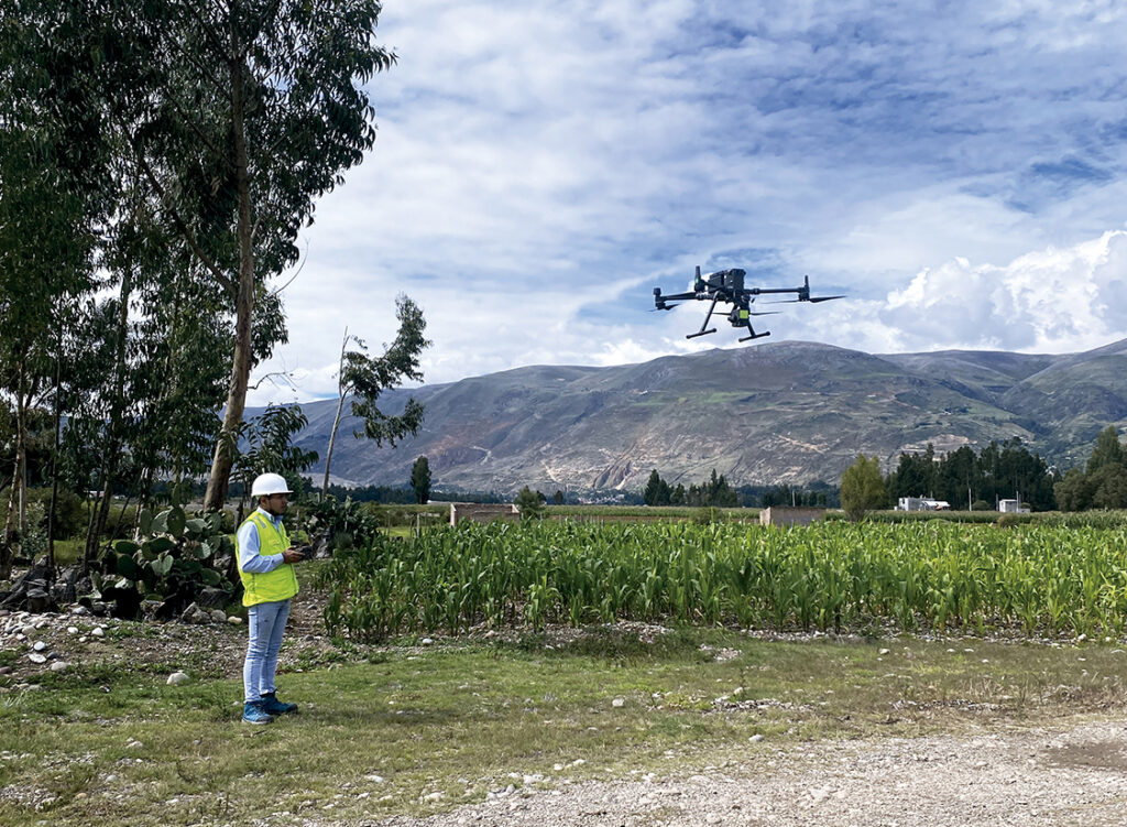
With the help of unmanned aerial vehicles, such as drones, airborne surveys have become more efficient. These include drone photogrammetry and LiDAR (Light Detection and Ranging), with the goal of capturing extensive data over large areas quickly and accurately.
These aerial topographic studies enable the creation of three-dimensional terrain models, useful for urban planning, environmental monitoring, and evaluating inaccessible areas.
Construction Surveys
Specifically designed for the construction industry, construction surveys aim to provide precise data for buildings. It is recommended to conduct them from site preparation through to the final verification of structures.
This type of topographic study ensures that buildings, roads, and other infrastructure are constructed according to design specifications and meet regulatory standards, preventing costly errors in project execution.
Boundary Surveys
Boundary surveys aim to define and delineate property lines and are essential for resolving land disputes, property transfers, and compliance with zoning regulations.
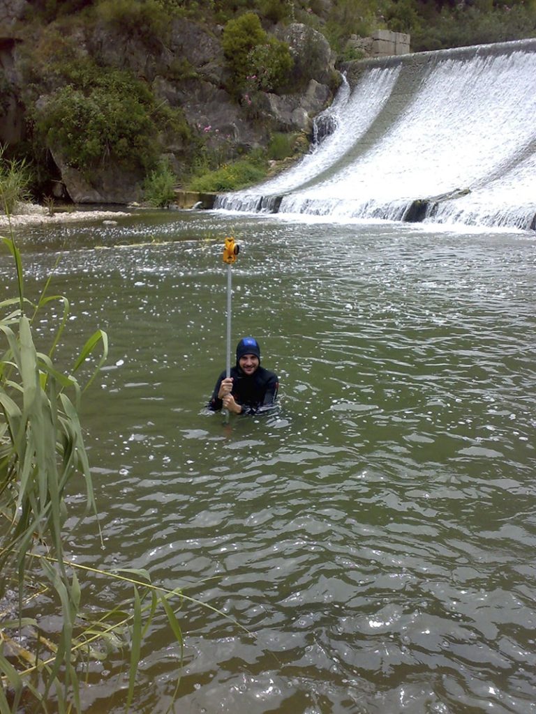
Hydrographic Surveys
The objective of hydrographic surveys is to map underwater features, such as depths, shoals, and obstacles. These studies are essential for navigation, marine construction, and coastal zone management. Thanks to this type of study, a detailed profile of the waterbed can be obtained for projects such as port dredging and maintenance of navigation routes.
If you want to learn more about our topography services, remember that Acero Estudio is a surveying company with 25 years of experience in Europe and Latin America. Contact us today — as a topography company, we are specialists and at your service.
Nuestra web está en reestructuración. Agradecemos su comprensión si algún componente del sitio no funciona correctamente. Para contactarnos: comercial@aceroestudio.com