Drones and their impact on the construction sector

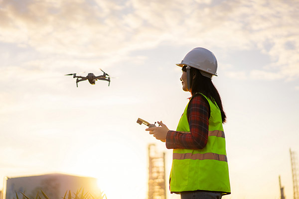
We are at a time when the use of high quality technology can become a fundamental ally when it comes to standing out in the market of different industries. In the construction sector, for example, the use of advanced technology drones means a simplification in the processes to carry out eminent projects.

The ability of drones to collect real-time data on the job site has dramatically increased workflow and efficiency in design and construction. Drones are most often used in construction to conduct site surveys. These capture a large amount of data that is usually inaccessible visually, as they have a point of view free of obstacles and at a great height.

Likewise, this contributes to a safer work, since the drones can inspect difficult or dangerous terrain, keeping personnel out of danger and avoiding transit through areas that could be dangerous. For all these reasons, drones are replacing traditional methods of ground surveillance and greatly reducing the time and manual work required.

According to a report in the scientific journal Journal of Unmanned Vehicle Systems, the use of drones for taking measurements and levels of a terrain, allows a reduction of working time of 50% with respect to drones. traditional surveying methods. In addition, it represents a reduction in lifting costs of 75%.

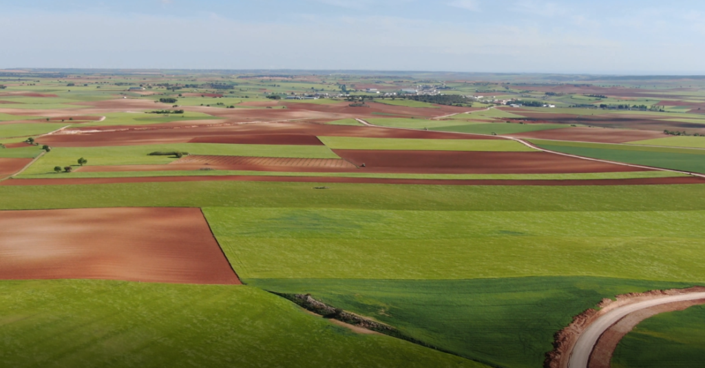
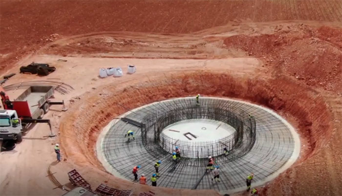
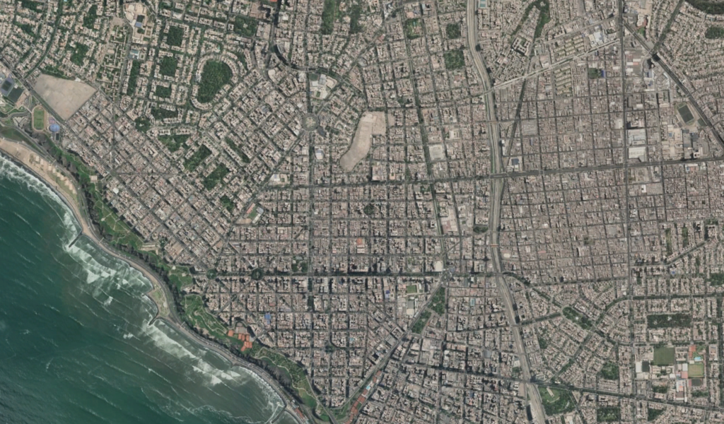
Our company, Acero Estudio, supervises the progress of the GECAMA wind farm in Cuenca, with the help of this technology and also offer surveying with drones.

We leave you some photos of the project and how the work is progressing.

The laser scanner like never seen before

robot 3d laser scanner

Capturing the environment using a 3D laser scanner sometimes becomes an arduous task due to the difficulty of accessing certain locations.

FARO has integrated its 3D laser scanner with Boston Dynamics’ Spot robot for autonomous point cloud capture. This integration focuses on automated capture and its main advantage is the increased efficiency and real-time data analysis as well as the ease gained in reaching areas that are difficult for people to pass through.

“Our customers in the construction industry need turnkey solutions for autonomous on-site documentation and analysis. Boston Dynamics’ strategic alliance with Trimble has allowed us to collaboratively build that solution by combining our strengths in robotics and construction, respectively.”

– Brian Ringley, director of construction products, Boston Dynamics

Without tools like these, scanning has never been easier. The combination between FARO and Boston Dynamics allows us to document on-the-spot changes on the jobsite and make important decisions in the field, rather than waiting hours or potentially days for information to be relayed to our project staff.

At Acero Estudio we like to stay on top of all the latest developments in the industry and we don’t miss a beat!

The essential support of drones

topografia y drones

Drone technology is advancing at exponential rates and is becoming more and more accessible, so different industries are leveraging and adopting drones in their work to dramatically increase their efficiency. In other words, drones are changing the way businesses operate by reducing costs, saving time, improving safety and providing a direct return on investment, so their impact should not be ignored.

In particular, the use of drones in surveying is a revolution. While the use of traditional methods brings more accuracy, the use of drones in this type of work, offers more survey area in the same time frame.

“There is a saying in the construction industry: ‘Time, cost and safety, choose two’.” And what makes drones really transformative for us is that we can pick and choose and improve on all three.”

– Grant Hagen, Director, VDC, the Beck Group

As we already know, the use of drones brings with it a number of advantages and each of these advantages has to do with their ability to reduce project time, danger and cost. However, another very important factor to consider is the following, are drones as accurate as traditional terrestrial methods of surveying?

For many years, the accuracy of drones has not lived up to their theoretical potential although this has begun to change. With drone solutions, a wide selection of surveying techniques are available that allow any project to be developed with excellent results.

In Acero Estudio we invest in drones for the development of this type of projects and the results are not disappointing. What are you waiting for to find out?

Outsourcing BIM

Take advantage of the knowledge, experience and commitment of a company with more than 20 years of experience in the market and the best professionals at your service.

Optimize costs and subcontract a service company for the development of projects that require BIM methodology.

Using this formula, as a client you will only pay, when you need it, for the final product without assuming fixed costs that harm your income statement.

Training, software acquisition, hardware, elimination of the learning curve of your staff among many other advantages make this formula the best option.

You will obtain results in the short term. In addition to maximizing the profit on your projects, you will be able to focus on your business while at the same time developing your BIM projects. This can be a differentiating factor with respect to the competition.

Outsourcing BIM services is an excellent way to minimize uncertainty and reduce time and effort when carrying out any type of project. At Acero Estudio, we ensure that each of our clients receives exclusive attention and guarantee that we deliver on time and at a competitive cost.

Have you not yet reaped the benefits of Outsourcing? For your next project to be developed in BIM, do not hesitate, outsource the service and take advantage of the many benefits we offer.

Contact us for any questions you may have.

Digital transformation is gaining strength in Peru

A couple of years ago, the BIM Peru Plan was proposed in the National Competitiveness and Productivity Plan, promoted by the Ministry of Economy and Finance (MEF). In July of this year 2021, the Technical Note of Introduction to BIM and the National BIM Guide were published, as well as the directive of pilot projects to implement this technology in the public sector.

According to the director of public investment policies and strategies of the MEF, by 2025 the regulatory framework for the implementation of BIM in the public sector will be published, as well as the technological platforms for prioritized sectors of the national government. It is expected that by 2030, BIM will be mandatory throughout the public sector through its respective standard.

The executive director of the Peruvian Chamber of Construction (Capeco) pointed out that the country has serious deficits in infrastructure, equipment and housing that affect competitiveness, in addition to the fact that the current public works model is inefficient. He also pointed out that during 2020, 44% of medium and large construction companies used BIM in the country.

It should be noted that this decision has been reached because, among the many benefits of BIM, it allows reducing up to 85% the number of problems in the works, as well as reducing change orders by 40%, reducing construction times by 7%, and saving from 1% to 5% in construction costs.

At Acero Estudio Peru we are on the cutting edge and we implement the BIM methodology in all types of projects to offer our clients the best results. What are you waiting for? Contact us to take advantage of the benefits of BIM in public works.

BIM and “Blockchain” combination

The Spanish construction company FCC has completed in Dublin the first project in the world to combine BIM and “Blockchain”, two buildings on the campus of the Grangegorman University. To achieve this, a platform has been created that pairs both solutions with the aim of improving the company’s productivity and guaranteeing excellence in processes and results through the automation of on-site quality control and management methods.

The use of the BIM methodology is mandatory to be awarded a public works contract in Spain. Its implementation is advancing at a fast pace and it is required for many different types of projects. So far this year, 161 tenders have been published for a total of 148 million euros that include this requirement, according to the CBIM Observatory of the Ministry of Transport. As we can see, BIM is becoming, day by day, a crucial methodology for the development of projects in the construction sector and therefore we should not overlook it.

It is true that both BIM and “Blockchain”, a distributed and secure database thanks to the encryption of its components, can be used separately and that there is already a lot of automation in the sector. However, by combining the qualities provided by “Blockchain” and BIM, the project gains in traceability and automation, ensuring quality, agility in the purchasing, monitoring and control processes, among many other things.

With a budget of 220 million, this first work to be carried out with both innovative methodologies has received the “Breeam” sustainable construction certification. Let us all follow FCC’s example and take advantage of BIM and “Blockchain”.

In Acero Estudio we have a team of professionals with proven and multidisciplinary experience in BIM methodology, contact us now.

Drones and their transformation of the AEC industry

drones industry AEC

Companies in the AEC (Architecture, Engineering, and Construction) industry are using drones to quickly and accurately collect survey data.

The architecture, engineering and construction industry has historically been slow to adapt to technology. In fact, according to a McKinsey Global Institute report, the construction industry is one of the least digitalized. This is underscored by another report, this one from JBKnowledge, which reveals that nearly 60% of construction companies are not investing in new technologies.

An increasing number of disciplines is expanding its use of drones

Much of the AEC industry is using technologies and processes that no longer adequately serve their needs, either for projects or for partnerships. However, one area where the construction industry is expanding its use of emerging technology is the use of drones. Estimates from PricewaterhouseCoopers put the sources of drone work for infrastructure at a market value of $45.2 billion. Today, an increasing number of disciplines within construction projects – such as designers, surveyors, environmental consultants, builders and inspectors – are using drones for aerial photography, volumetric analysis and topographic mapping, among many other things.

Benefits of using drones:

1) Helps to increase workflow and efficiency

The ability of drones to collect real-time data on the job site has dramatically increased workflow and efficiency in design and construction. Drones are being used more frequently in construction to conduct on-site surveys, as in the case of our company, Acero Estudio, monitoring the progress of the GECAMA wind farm construction site in Cuenca with the help of this technology.

The drones capture the data that the surveyors need but cannot normally see, since they have an unobstructed, high-altitude view of the construction site.

Drone inspection
Drone inspection in the GECAMA wind farm construction (Cuenca – Spain)

2) Helps to make the construction site safer

This also helps to make the construction site safer, as drones can survey difficult or dangerous terrain, keeping human surveyors out of harm’s way and helping construction workers avoid dangerous areas. For all these reasons, drones are replacing traditional methods of surveying terrain and greatly reducing the time and manual labor required.

Supervising construction with drones

3) Time and cost reduction

It is ironic that the AEC sector is one of the slowest to adopt new technologies, yet one of those that could benefit the most from them. However, this sector has more readily adopted the use of drones, which can save large design and construction projects a lot of time and money.

According to a report in the scientific journal Journal of Unmanned Vehicle Systems, the use of drones for taking measurements and levels of a terrain, allows a reduction of working time of 50% with respect to drones. traditional surveying methods. In addition, it represents a reduction in lifting costs of 75%.

Acero Estudio has just incorporated a fleet of DRONES

Acero Estudio, with headquarters in Valencia and based in Perú, incorporates a fleet of DRONES capable of developing most of our services faster and with more efficiency, following our commitment with the integration of new technologies in our servicies.

>> SEE WHAT WE CAN DO FOR YOUR COMPANY


Contact us if you need more information

Drop files here or
Max. file size: 16 MB.
    Aceptación(Required)

    Mercadona launches innovative BIM processes

    Today, more than ever, we know firsthand the impact that unexpected challenges can have on our jobs and how many project management teams have been forced to quickly devise new, secure methods of communication and collaboration in order to keep their projects on track.

    Mercadona, Spain’s leading food retailer, is not only a major retailer, but also designs, executes and maintains logistics blocks, stores and offices. With more than 1,600 stores, 16 logistics blocks, 3 beehives and several office centers in Spain and Portugal, Mercadona is one of the Spanish companies with the highest construction volume.

    To be able to act against this market pull, it is necessary to build adequate spaces where digital transformation becomes essential. Thus, Mercadona has organized itself to build efficiently and, in particular, has implemented innovative BIM processes. The goal is simple: to build better, faster and in a respectful and sustainable way thanks to the BIM methodology.

    Mercadona relies on the Onfly solution, which makes it possible to implement the established procedure. Onfly is a simple and effective tool for managing, centralizing and harmonizing BIM data to speed up design and increase team productivity, provided by the BIM&CO digital community. This shared BIM library helps construction companies to manage and share their BIM content in a private and secure cloud-based way, taking into account classifications and business data specific to their structures.

    If you want to imitate Mercadona’s model and improve your construction process considerably, don’t hesitate to apply this innovative methodology! To learn more about BIM, take a look at our website or contact us. If, on the other hand, you are interested in the Onfly solution for your company, have a look at the BIM&CO web site.

    Participation of Acero Estudio in the international program XPande

    XPande. Application for growth in international markets

    “This action is co-financed by the European Union through the FEDER Operational Program of the Valencian Community 2014-2020”.

    This year 2021-2022, in Acero Estudio, we have had the opportunity to participate in the Xpande Digital program of the Chamber of Commerce of Valencia.

    Through this program, the European Union has granted us financial support through the European Regional Development Fund, allowing us to carry out the internationalization of our company in the UK market.

    With some objectives to achieve, related to our presence on the Internet, such as strengthening our global online activity, achieving brand recognition, attracting new customers, building customer loyalty and increasing the number of sales (or market share), we have finally achieved great results. Among them, the possibility of entering a new market such as the United Kingdom and increasing the visibility of our business in this country, thus achieving the consolidation of our website abroad.

    We thank the Chamber of Commerce of Spain and Valencia, the IVACE and the European Union for the opportunity to participate in this program.

    Drone flight and restitution of the area planned for the Pedestrian Accessibility to and from “Las Estaciones del Metropolitano, Lima”

    estudio conceptual para restitucion accesibilidad metropolitano de lima

    The Acero Estudio team in Peru carried out the geodesy, drone flight and restitution of the area planned for the Pedestrian Accessibility to and from “Las Estaciones del Metropolitano, Lima”.

    Given the current situation of global pandemic due to COVID-19, these tasks were all carried out under preventive measures and medical examinations.

    To better understand the work developed by our team in the project area, they began with the placement of Geodetic Points (one at each station) linked to the IGN coordinate system. The measurement of the same by means of differential GPS of double frequency. Then, we proceeded to the location of the support points necessary for the subsequent restitution of the drone flight. These support points were marked with X-shaped stencils and paint, and were measured with GPS in RTK mode.

    The drone flight of the 33 stations was performed at a suitable height taking into account the height of the buildings and the existing elements. A DJI Phantom 4 Pro drone with a 20 Mpx camera was used for this purpose. Once the photogrammetric images were obtained, they were processed and the point cloud and orthophoto of each station were made. With the orthophoto and the point cloud, the DTM was processed and then the restitution of the environment of each station.

    We would like to thank our client CPS for the trust placed in our team and for the coordination and management of the work carried out.