Topography with drones

There are many reasons that make topography and drones a perfect combination.

The applications of drones in topography are many and quite different, but among its most common uses, the supervision of works and facilities stands out from the rest, in which Acero Estudio has a lot of experience.

The study of an area for a future action, mainly large public and civil constructions, is crucial in order to examine in detail the environment in which it will be developed. Drones allow to make revisions and visually detect possible conditioning factors in the subsequent execution, in a fast way and with a high level of accuracy.

In addition, drones in this field allow us to obtain high quality images and videos that helps facilitate the presentation and analysis of the progress of the constructions.


BIM in railway infrastructures

The rail transport system plays a crucial role in cities, allowing both the orderly growth of the urban planning and the movement of millions of people and goods in a sustainable way.

The development of rail projects requires large investments and long, particularly laborious, processes, so the integration of new technologies from the initial stages is essential.

Among the most significant difficulties are the massive processing of information data, long execution periods and the complexity of construction due to the surrounding work environment. The needs of the sector have given rise to the search for optimal answers to improve the efficiency of construction and operation of project development, as well as to guarantee its progress, safety and quality. The Building Information Modeling (BIM) methodology is used to meet these specific needs.

The application of BIM in the railway sector offers comprehensive project management and the opportunity to win at all stages of its life cycle. It meets customer demand with information models created in a common data environment that enables effective collaboration and communication between all stakeholders. Accordingly, the development of the technological foundations makes it possible to explore the pre-construction of infrastructure through simulations, to assess its feasibility.

BIM is a key player in the industry. In the long term, its contributions are immeasurable and promise greater benefits in the operation and maintenance phases. BIM methodology is currently being used in 21 rail projects in 17 countries.

BIM applied to the nuclear energy industry

scan to bim central nuclear

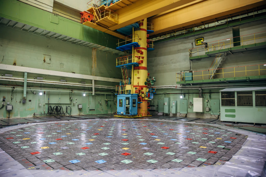
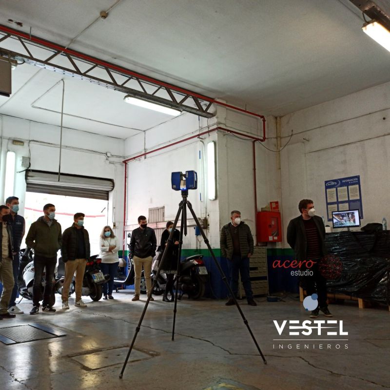
In the nuclear power plants : Vandellós II, Almaráz and Cofrentes, under the direction, coordination and management of GDES (Grupo Dominguis Energy Services), our team has been in charge of the data collection of existing electrical conduits and the three-dimensional modeling. Because of our commitment to excellence in safety and reliability and of course our large track record  in such industry, our client has opted for our Laser Scanning and Building Information Modeling (BIM) services.

Scan-to-BIM and its benefits

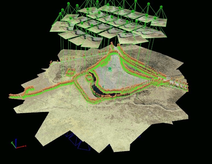
The Faro Focus 3D x330 scanner was the tool used to perform the surveys of the electrical ducts and collect all essential information with point clouds and volumes of high quality images. From the data obtained, with the use of BIM and Revit, three-dimensional models of the current state were created, to subsequently include the designed endothermic protection solutions (fire protection) and obtain their measurements with high precision.

The Laser Scanner has simplified the data collection process, getting a significant reduction in the risks involved when we work at heights, accidental actions with the equipment necessary for manual data collection and exposure times of personnel; translating in terms of occupational safety and nuclear safety.

The benefits of the use of these technologies are transcendent, in addition to obtaining accurate and structured data, it offers the opportunity to provide optimized solutions, which contemplate a greater number of data and factors for the design.In turn, it is possible to better plan actions, increase safety, avoid future problems and, consequently, increase the efficiency of nuclear power facilities.

We would like to thank our client GDES for the trust in our team.

Acero Estudio sharing knowledge

On Tuesday, the 30th of March, we had the pleasure to share with Vestel Ingineering our knowledge and experience working with 3D Laser Scanner and drone technology.

With the help of Juan Antonio Ortiz Rodríguez and David Torromé Belda, we showed the different advantages of both technologies and the importance of having a drone and thermographic camera in data collection.

We would like to thank David Mora Negrete and Ricard Martínez Pla, among others, for their great welcome. It was a very interesting day and, most importantly, with an audience very interested in the content!

Given the special circumstances, the event was carried out respecting all security measures. The training was carried out in shifts and in a place with enough space to carry out the activity with the peacefulness that we all need during these times.

If you are also interested in training and would like to learn more about these innovative technologies in the industry, take a look at 3-D Laser Scanner and Drones.

Drone – UAV’S – RPAS

New service in Spain

The incorporation of new technologies is part of the spirit of our company. Among the different services we offer, we can find the service of drones in different fields of application, specially developed for years in the Delegation of Peru.

Taking advantage of the knowledge and experience acquired during these years, we have incorporated this service in Spain in order to help all our customers in their projects in the fastest and most effective way. For this purpose, we have a team of drones, qualified pilots and operators, trained to develop any project.

The result of this expansion of drone services through a strong commitment to this technology is a reality. Thanks to the use of drones, we can combine topography and photography, thus obtaining cartography, digital models and orthophotos in different types of activities; civil engineering, industrial, archeology and architecture among others.

There are many advantages that are achieved by applying this technology in projects, so what are you waiting for? Visit our website and contact us for more information.

Acero Estudio at EXPOBIM 2020

expo bim

Our BIM expert, Álex Ruiz will present the lecture “Laser scanner and point cloud” at EXPOBIM 2020.

On November the 5th, 6 th and 7th EXPOBIM” 2020 will be held, where Álex Ruiz, from Acero Estudio Peru, BIM Consulting Department, will present the symposium “Laser scanner and point cloud” at the Catholic University of Lima. The congress will be broadcasted through Zoom and Facebook live and will have as speakers, prestigious international experts.

On Thursday the 5th, the event will start with the engineer Pablo Zuñiga Guevara, with his presentation “BIM application in construction projects in Colombia”, and will be followed by the architect Sergio Villanueva-Meyer with “Innovation methodologies in the construction industry”.

On Friday, the two presentations are “BIM from the technical side”, by the engineer Jonattan Gómez Araya and the day will end with Renzo Ríos Rugel who will take about “Automation in BIM”.

The last day, Saturday the 7th, will begin with “Infrastructure in BIM” whose speaker is the engineer Alejandro Alvarazo Lezama, and to finish the event, Álex Ruiz will expose the symposium “Laser scanner and point cloud”, an expert in photogrammetry and 3D laser scanning of the Acero Estudio team in Peru.

An essential event for all of us who work with BIM in the construction sector.